Showing posts with label Hwy 74. Show all posts

Thursday, May 16, 2013

Preview: Highway Department's South Fork Canyon Stream Course Reroute & Diversion Scheme

Image Credit:

Wikipedia - Prunus ilicifolia
Mostly with this preview Post here, I want to show an example of an incredible find We (Myself, Patrick Dennis and Mary Ann Kiger) found on our South Fork San Jacinto River Trail hike off Hwy 74 of an old growth Chaparral plant that many here reading are already aware of, but probably have never seen a specimen of this extraordinary size. The plant of course is Holly Leaf Cherry (Prunus ilicifolia). We were on a hike on the South Fork San Jacinto River Trail to photo document the old Highway 74 construction manipulation of a major stream tributary of which drains most of the north face of Baldy Mountain's old growth forest which is just south of Mountain Center. Making the deliberate stream diversion saved the Highway construction several 1000s of dollars in bridge building costs by instead installing a pathetic little culvert by comparison. But the cost to the environment was much greater in the long run as i will later show in a future post. First a description of a rarely seen giant. In the upper right hand corner above here is an image from Wikipedia which also has a description about the actual size of the Holly Leaf Cherry as being any where from 8 foot to 30 foot in height and leaves any where from one to two inches in length. Okay, most of us have maybe seen the 8 to 10 foot examples that we thought were huge and which are easily found in many places. But 30 footer trees ? With recent decades of mega-fires, any giant specimens would surely be a rarity. This last leg of our hike was not exactly through any well worn trail, but rather true bush whacking. In fact it was at the very end of the hike, but took us the longest to finish. The example below might be pushing close to 20 foot in height, but I'm not sure. It did take your breath away when you first stumble upon it. Clearly though as you first encounter it, it's very large features first cause you to think it is something else, but you soon realize many of the familiar identification marks. Here is the first photo looking down from the formerly very large flowing stream bed towards the San Jacinto River valley and other tributaries like North Fork, Strawberry Creek, Cold Creek and Dry Creek. Hemet Valley and the town of San Jacinto are to the left in the photo.

photo credit: Mine 
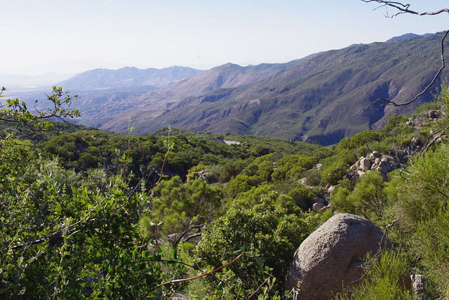
Looking north from the upper reaches of the old now long diverted large flowing stream which now empties west into South Fork Canyon and eroding the entire hillside in that region. There were no trails here. Everything from this point to Hwy 74 was true bush whacking through dense chaparral which was incredibly still very moist with a rich heavily diverse abundance of chaparral plant community supporting an incredible amount of wildlife life.
Photo Credit: Mine

Here you can see the Holly Leaf Cherry which at best is maybe 30+ feet in height. Unfortunately the camera really doesn't do it justice. This entire area was devastated by arson set fire some time back in the 1990s which was I believed named either the South Fork Fire or Baldy Mountain Fire, but it happened in the 1990s some time ago. Notice the old long dead burned branches. This also made the last leg of the hike most difficult as the stream bed was loaded with all manner of down trees and their branches. Also, with the canopy opened, massive amounts of Poison Oak made other stumbling blocks with going forwards, so adjacent hillside brush whacking was the only way to go in short sections.
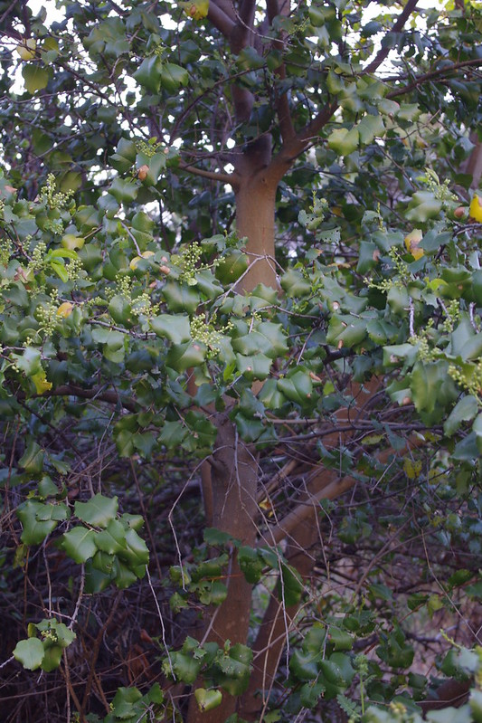
Photo Credit: Mine

This is a close up shot of the beautiful interior of the tree. Notice the clean smoothness of the almost perfectly straight multiple trunks, The colour and texture of the trunk is reminiscent of the sapling growth of a Fruitless Mulberry tree when cut back very hard to a few main branches. Seeing the stunning large attributes of this Holly Leaf Cherry made you wonder what it may have once looked like pre-turn of the century Baldy Mountain Fire. That fire burned all the way from the Hwy 74 CalTrans gravel bunkers or bins and the South Fork Trail head all the way east to Lake Hemet and Hurkey Creek Campground.
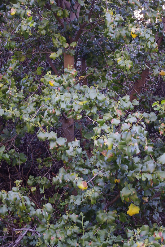
Photo Credit: Mine

This is another angle of the tree's interior further up. In another post later I'll show much of the biodiversity in plant life, much of which is still riparian. In fact, though up stream the diversion was deliberately routed west instead of allowing it to continue northwards as the geography dictates, the water still must somehow be moving underground to still support such moisture loving plants. The newer unnatural creek channel even to this day DOES NOT support such an abundance, with the exception of some Bunch Grasses. Mostly though it is a dry wash with shear steep walled erosion on both side.
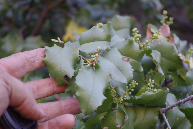
Photo Credit: Mine

Here is a close up of the very large size of the leaves. I'm using my adult male hand here for some sense of scale. Unlike the smaller specimens we saw on the trail above and to the west of this location, this one was not yet in bloom, other than showing signs of buds. This great largeness was such a pleasant shocker when we turned the bend and there were other more large leafed examples further down stream. I truly wish there had been berries, as I'd love to collect samples. When I looked for chaparral seeds in the past decades ago, I'd truly be looking for such beautiful examples.
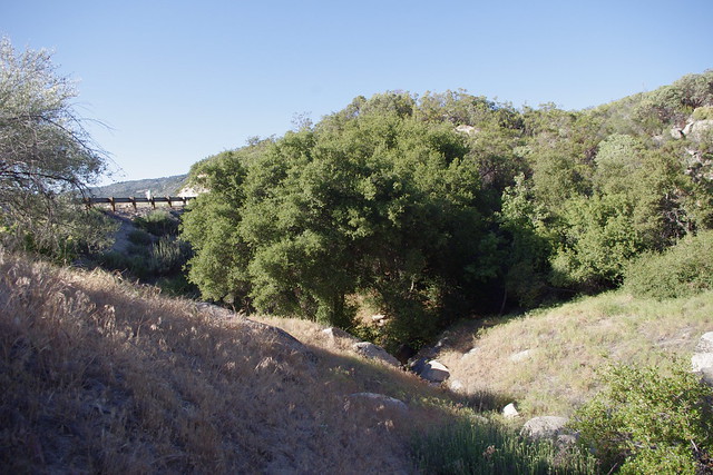
Photo Credit: Mine
And here is the highway, which should have had a bridge or at least an extremely large concrete built double culvert. I can't for the life of me tell you what the name of this old stream was once called, although you will find it on older Topo maps showing it's original course which turns sharply northwards. But it does drain from the flat meadows and McGaugh Lake to the east of this point for which I have written about before.
Photo: Mine
Patrick Dennis and Mary Ann Kiger (both Anza residents) with me on the hike. Patrick with the short pants had the bright idea of following the former stream bed back down to the Highway. We weren't all in favour, but I'm glad we did. He led the way in eventual brush whacking a trail down in some parts.
Idyllwild Postcard - Riverside Co.

Highway 74 as it was in the early days as an original dirt or gravel Wagon Road finally to paved road in 1937-40s coming up from Hemet Valley in the background to Mountain Center with either Lake Hemet or Idyllwild as a final destination beyond.
There are certainly more answers that need to be found on this unnatural disaster and the reasons for which a channel was deliberately cut diverting a beautiful stream bed into another completely different direction which caused and indeed continues the collapse of an entire mountainside which is truly hidden from public view. In a future post I'll show the entire trek we made and the detailed photos showing the unnatural river bed and comparison to the older 1000s of years old historical stream bed. Clearly, saving money on bridge construction costs were the motivation. It's obvious that in it's early days, this section of the old dirt wagon road of the Hemet to Idyllwild highway no doubt washed out several times and was a pain to fix, hence the great effort made to use hand crews to dig another channel and provide a diversion berm of rock and sandy soil to divert the flow westward instead of it's historic northward course. Nothing in any historical records or other writings even remotely hints at such a major riparian diversion to save money in road construction. Clearly a bridge or at least a  major double concrete culvert should have been constructed. More on this later. 

Next post will focus FIRST on my reasons for something not making sense for such a rich riparian habitat being present and spilling out of the chaparral plant community for no apparent reason. It was actually over a period of years from my employment commuting up and down the hill on Route Hwy 74 that got my curiosity from observing out of place plant community anomalies that defied the surrounding chaparral vegetation by contrast.
Update: Here is the link to the main article: 
Cal-Trans Diversion of Baldy Mountain Creek Shut Down One Ecosystem and Destroyed Another


Sunday, December 23, 2012

Santa Rosa Mountain Above Palm Springs: Part I - "Spring Crest"

Image from Press Enterprise
Press Enterprise: BACK IN THE DAY: Ribbonwood was popular rest stop

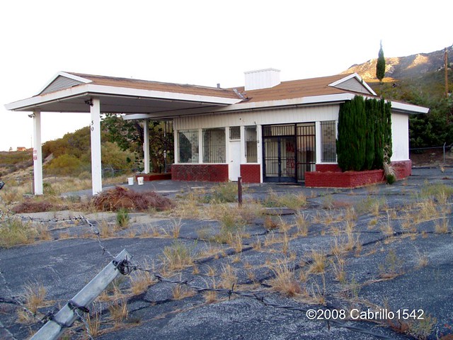
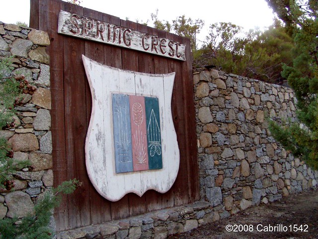
Well that photograph above isn't exactly what people think of when they picture the housing development along Hwy 74 (Palms to Pines Highway) on Santa Rosa Mountain which is more commonly known as Spring Crest. You'll notice of course in the photograph to the right, that the location (which is exactly Spring Crest) was at one time called "Ribbonwood".  Of course that would certainly explain the crossroads sign as located near the old abandoned Gas Station which hasn't been used in decades. 


Oct 2008 - Cabrillo1543
More commonly people are more familiar with the old abandoned Gas Station that hasn't operated in several decades. Take a look below at what most people see when they drive past modern day Spring Crest. Of course several famous folks have had private homes here. Red Skelton had two of them, though I'm not sure if his wife Lothian has them. One was an A-frame house on the top street overlooking this station and another is at the end of the cul-de-sac (deadend street) which is the first street on the right after passing this station. It was always a larger house and sort of a mini ranch home. They never truly lived there, but preferred the modest A-Frame house. Although they purchased that large 660 acre horse ranch in Burnt Valley and I believe this is where Lothian resides now, but I could be wrong. 


Cabrillo1542
Hwy 74 passes right by Spring Crest and it was here that the above photo locates what was originally called Ribbonwood. Highway 74 is part of that "Palms to Pines Scenic Highway" that was built between 1929 and 1932, finally opening in 1932. As with most of the early highways back then, many entrepreneurs seeking to create business along the highway built little roadside gimmicks to get people to stop and purchase any souvenirs or services before heading on down the road. The roadstop station along the Palms to Pines hwy 73 called Ribbonwood was founded by Wilson Howell. It was a sort of early primitive rest stop for tired travelers who I am sure were ragged after enduring the early rough road conditions back in those days.

Rancho Fruit Market in Temecula


Image from Foursquare
This is probably one of the earliest roadside Fruit stands which much much later became very up until this very day. Hmmm, somewhere at the end of this road with a detour left turn at Paradise Corners to Anza and beyond, there use to be the well known stop called Rancho Fruit Market in the Temecula area right on Hwy 79. It has now moved to old town Temecula after a fire and redevelopment of the land it was once on. But Wilson's place was also another place where one could buy fruits and  vegetables, enjoy a cold drink under an old Ramada (probably made of Redshank) or even rent a Cabin or Kamp spot for the night. Maybe even the weekend. Notice the skyline in the background of Santa Rosa Mountain ?

I found another bit of history that I had read many years back and now it has even been more recently updated. I think readers will find it both sad yet interesting at the same time. In 1959 there was a mystery of sorts surrounding the disappearance of a young woman named Louise Teagarden. She was an outdoors person and friend to even Wilson Howell at the Ribbonwood Camp where she learned much of her outback survival skills. Yet strangely enough on this one occasion, she lived for a couple of months in the wilderness before dying. Her remains were not found until 1991 in a cave in the Palm Canyon Drainage area of which the Spring Crest area (Ribbonwood) on Santa Rosa Mountain is very much a part of the upper headwaters. The Sierra Club actually published an interesting story about Louise Teagarden, who was very experienced as having  outdoors survival skills and yet she mysteriously died. Rather than tell the story over, you may read it for yourself here. 
Sierra Club: "Lost and Found" - Louise Teagarden's Death Still a Mystery
For those a bit more on the impatient side (you really should read it though), there was also a video of the recent 2008 search made for that very cave where she was found. It's only about ten minutes. Writer Ann Japenga, Harry Quinn & Theresa Pawley are making an attempt in the video to locate the actual cave where Lousie Teagarden's remains were found over 30 years later. Very interesting and informative video.


Image - SummitPost.org
Hope everyone enjoyed a bit of forgotten history about this Spring Crest area of the Santa Rosa Mountains. On a very special note, I want everyone to know that when I come back for a visit next year, there is a place almost exactly halfway between that Spring Crest Gas Station and the entrance of Santa Rosa Indian Reservation which has a single sentinel Jeffrey Pine tree right next to the road on the side where travelers would be heading east towards Spring Crest. Not far from the Santa Rosa Truck Trail Forestry road actually. You can find it here on  Google Maps . This of course would be the south side of the Highway 74. Incredibly, on this same Google link, you can click on Satellite tab and zoom in as close as possible at the junction of Hwy 74 & Santa Rosa Truck Trail. proceed west and then just around the bend and down a short grade you'll see this Jeffrey Pine tree over on the left side of the highway. 

After 24 years of traveling this highway back and forth to work, I always passed this single lone beautiful tree and wondered about it. Where did it come from and why is it here of all places miles from any other group of Jeffrey Pines ? This isn't the first time I wondered about how and where certain species of out of place species of trees came from. Hwy 74 west of Mountain Center was another example, which I have previously alluded to in in an earlier post of my discovery of the road construction of Hwy 74 which completely & very deliberately diverted an entire stream (almost a small river) by means of a bulldozer and cutting a path towards the South Fork of the San Jacinto River Canyon. The result is an entire mountainside washed & fell away in a landslide at that canyon with no real possible way of repairing it. And amazingly no one noticed or at least has admitted this. More on this after I actually go out and photograph this area next summer. Incredibly, some extensive Chaparral removal has been conducted around this tree and on up the hillside. Some things never change.


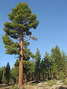
Wikipedia

Example of Jeffrey Pine. Much
larger than the stunted Hwy 74
lone pine tree, but from where
did the original seed come from ?
But what I found around the hills and dry washes around this tree and other canyons north of Hwy 74 in the Palm Canyon drainage were several large (actually huge) Jeffrey Pine stumps and the reason for their continued forensic existence. They still existed because they are completely charred by some historical forest fire which burned who knows when. But traveling back and forth on this road and seeing the rugged chaparral all around, one would never in a million years guess such large pines once existed here. Even as I stood there looking at these as I found them, I was still blown away. I have long suspected that forests were more extensive  and existed further on down the mountain at lower elevations, especially several hundred years back when ancient Lake Cahuilla once exited. Who knows, maybe the climate was more moderate back then. I have wondered and even imagined that more than just the Colorado river contributed to the maintenance of ancient Lake Cahuilla. Wondered whether the White Water River was bigger and greater than it is now. Did Palm Canyon Creek, Tahquitz Creek Canyon and Deep Canyon (Horsethief Creek) water courses also contribute to Lake Cahuilla ? Ultimately I don't now, but I'm still intrigued about the ancient possibilities. 

Tomorrow I'll have Part II which will focus attention on the switched back logging road you can easily view from Sugar Loaf Mountain Cafe. I'll tell you about the man who built that road and the conversation we had on why he was contracted to build it. Much of of the story he told sounded like forestry politics as usual. 

~~~~~~~~~~~~~~~~~~~~~~~~~~~~~~~~~~~~~~~~~~~~
Of Further Reading Interest:
http://www.palmspringslife.com/santarosa/
http://www.annjapenga.com/Images/articles/wHwy74.pdf
http://www.riversidecountyhistory.org/SJM.htm
http://www.santarosacahuilla-nsn.gov/home.htm
http://www.annjapenga.com/Images/articles/wLostandFound.pdf