Travels in Canary Islands - Part II
Canary Island Pines landscape plantings on the exit of Interstate-8 & Tavern Rd in Alpine, California
 |
| Image from Wikipedia.org |
Heading east from San Diego California and turning off at the main exit 30 to central town center at Tavern Road in Alpine, you will see all four east and west bound on & off ramp exists landscaped with these tough non-native pines from the Canary Islands. They were water in the beginning by the Road Maintenance crew from Cal-Trans using a tanker truck when they were first planted. I doubt they use this today. In fact I'm sure the pines are left to their own to merely survive off what ever minimal rainfall the area gets each winter and spring. Here is a google maps link to the location. Couldn't find any images on the web where someone has photographed and published them, but I'm sure someone have before. Click on the magnification to bring the on & off ramp exit into full view and adjust directional arrows accordingly. Notice the thin narrow form of the pines as opposed to how they appear in many landscape and in the Canary Islands themselves.
Interstate-8 and Tavern Road, Alpine, California
Now a really kool thing to do is once you've magnified that image as close as you can of the Motorway and Tavern Road exit, look over to the upper left hand corner where that Zoom in-out control is and click on the golden yellow man and hold and drag this clipart down to the point on the map where the arrow should still be on the exit. For those who've never taken a Google Maps road tour, this will be fun. Once there you can use those controls to pan around in any direction. You'll first want to point it towards the exit approach off the freeway heading to the top of the ramp. Half way up you should pan to the left and see the Canary Island pines I mentioned above. For those who don't know, you can drive forwards on the road by click the arrow on the pavement on the imaginary golden yellow line. If you just click the arrow, you'll move slowly. Move your mouse forwards on that line and click further ahead will allow you to go faster. I hope this instruction made sense, because now you know how to further take a road trip anywhere in the world where they have applied this technology on a road cruise.
Charlie Hohn of Slow Water Movement - blog did an article also on the Chaparral issues I wrote about previously. He had a picture in there of some Canary Island Pines for which the US Forest Service had planted I presume as an experiment plantation way high up in the San Gabriel Mountains above Los Angeles. Here is the picture from Charlie's blog photo which can be seen from his Flicker page.
 |
| Photo by Charlie Hohn |
You'll notice the same slender pattern in both outplantings by Cal-Trans and the US Forest Service Plantation up in the San Gabriel Mountains - Angeles National Forest which experimented with many different trees back in the 1920s. Yet once again under landscape irrigation they appear much like their parents over in the Canary Islands. Clearly even as tough a survivalist as they are, they apparently require more moisture than the wilds of Southern California rainy season contribute for them. The Canary Islands themselves are a more Subtropical ecosystem than the dry mediterranean of So-Cal. And of course that is the point of this post as an addition to my previous Canary Island trips and photos. On a special note - They colonize great with Pisolithus tictorius (Dog Turd Fungus) even in the city, which is something I doubt exists on their roots in those photos above.
Okay, now to the Canaria Travel from February 2012-
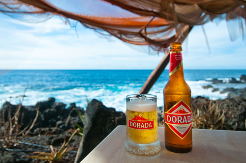
These next photos will be a collect of our first and second trips there and what we saw and experienced driving up into the narrow steep passes of the volcanic mountains themselves. First off, there is a place we stop at along the coast called Restaurant El Burgado, Buenavista del Norte, Tenerife. It was right next door to the Golf Club there in a public beach access park. The weather was perfect 25Celsius ( 77 Fahrenheit). Definitely T-Shirt, Short Pants and sandles weather. Humidity was perfect also since that is what makes it so comfortable. We heard back at our Hotel in Puerta de la Cruz that a storm could be moving in and we wanted to get ahead of it by driving towards the west and then south. We did spend a couple of hours there as the scenery and fresh air were just perfect for relaxing and kicking back. One of those times you could easily fall asleep and dream. So here is what we saw starting with pulling up to the restaurant El Burgado which is at the foot of the Buena Vista Golf Club. At first it wasn't open for food so we just had a couple of cerveza Doradas.

Once we walked up into the restaurant patio, I couldn't believe they landscaped with Tamarisk trees. Seriously , TAMARISKS ????? Okay to each his own and it is more native to Africa a part of which those islands are situated off the coast of Africa. But then what came next made me forget. *smile*
We actually got a front row seat too for watching the incredible rugged volcanic coastline and growing waves as the storm surge was approaching from the northeast. This first shot is the view looking straight ahead at an area we would later drive up and pass through a tunnel to the other side which is pretty isolated, but kool.
Now to my left of that shot are the crashing waves that kept getting bigger until we decided it was time to leave.
So then in the last picture you can see the dark clouds and storm surge getting stronger and we decided to head out of there quickly.
This next photo comes from a Tenerife web shot page, but it is a view from the air looking at what is on the other side of that tunnel up high and looking back at where we had been. Really kool picture. To the left of this tunnel shot were two more much longer narrow tunnels we had to drive through with our lights on. The picture shows all of the Green Houses and Banana Plantations which are all over the island. In many ways this place looks and feels like Hawaii with a squeaky clean hispanic twist.
Here are the light house and other steep cliffs looking towards the south point of the island.
 |
| Photo Mine 2012 |
 |
| Image Mine 2012 |
 |
| Image is Mine 2012 |
This side of the island was kool for no other reason than it was mostly wild. The steepness of the volcanic island mountains dropping abruptly into the sea was amazing and water was crytal clear and beautiful. Definitely a sort of Hawaiian Islands look about it. We unfortunately had to head back out those tunnels we came through and then back track through a steep narrow valley on our way to Masca which I wrote about in part one. Here are some pictures along the way.
The roads can be a bit spooky, but they also remind me of some of the old James Bond or other 1960s spy / intrigue flicks from the 1960s with those car chase scenes along the steep coast around the Mediterranean. Even Cary Grant's movie "To Catch A Thief" with the car chase from the police. The road above where the rock wall is we quickly had to dodge a public bus which had to make several back and forth maneuvers to make the hairpin turn.
More later in a part three series of the Laurel Forest side of the islands and the gardens in Puerta de la Cruz.


I cannot wait to re-read this post. Very cool...my parents lived in Morocco 2X, but that was before I was born. Looks great.
ReplyDeleteI actually think the Tamarix spp. / Salt Cedar trees look good on the beach. Aren't they native in southern Spain, too? I recall seeing them on some spaghetti westerns shot there, which was pretty wild.
(they are in full bloom here...I think we have 2 or 3 species, except the big Athel tree which is not hardy in cooler places than Presidio or Tucson)
My third part will be walking around photographic landscapes in peoples yards and the Botanical Garden. Also the northeastern part of the island where it is alot like a subtropical rainforest.
DeleteYeah the Tamarisk are native to not only around the rim of the Mediterranean, but also North Africa and Middle East. I don't think they are necessarily a native to Canary Island because for the most part I've never seen them in the wilds there. Only as a planting in the landscape. They don't really have any riparian habitat as we know them. The entire island is composed of this rugged jagged volcanic rock, in some places very vicious looking. Incredible that certain things find a niche there.
I love hispanic settings and architecture, but I don't think I'll ever go back to Mexico. The Canaries are entirely different when it comes to all things Latin. They just don't have that 3rd world dirtiness about them as in the Mexican border south. Everything is squeaky clean and decent. Very very pleasent place to go and I'll have to bet most Americans have never thought of going there. It's also cheaper than places like Hawaii, so the expense distance in traveling should be offset by the cheaper prices on everything overall.
I have always wanted to visit these islands. Living in Cape Verde, I was busy on the islands of Santiago and Sal. Some of the plants that they would attempt to grow on their properties was at times shocking....some of them not very xeric at all!!!
ReplyDeleteReally gorgeous shots of the beach....and the drinks do make you forget all the shortcomings that the islands perhaps "lack":) What's really shocking is how green Tenerife is! Is that the greenest spot out of all the islands? I know we had Santo Antao as our green island....but I lived on an island of dunes...sand dunes....very little plants.....sad sad sad times. Very little plant life at all. Devastating for this gardening:)
Actually most of those pictures are on the northern side which is more subtropical. I'll post some others from the southern side which has more of a desert look. Grand Canaria is the island where I believe that icon 1960s film "One Million Years BC" was filmed. You know ? The one with Raquel Welch ?????
DeleteI've actually got some contrasting shots of both sides of the island when we were on top of the Laurel Forest hwy. Also I've got some incredible Bouganvilla shots for another post.
That road reminds me of Chapman's Peak and Hout Bay. Before the heavy engineering and the toll road, and the current battle about building a toll plaza on National Park land - destroyed the charm.
ReplyDelete