Showing posts with label deserts. Show all posts

Thursday, June 15, 2017

Tucson Arizona: Regenerating Parks & Parkways through Biomimicry of Floodplains

2014 Regenerative Parks and Parkways: Local Harvests and Enhancements in Our Community Commons in Tucson Arizona
presented by Brad Lancaster
What is the story of your own place? What is your role in that story? What is the role of your public land (parks, parkways, rights-of-way) in that story? The Santa Cruz River was still a free flowing Sponge-like Drain in 1904 Tucson, Arizona, U.S.A as you can see in the photo below. This river use to flow year round. The Santa Cruz river in 2007 Tucson has been turned into a dredged out straightener &  deeper channel through Tucson as land was considered too valuable on either side for Cottonwood Forests and Mesquite Bosques which once acted to percolate water into the deeper aquafir like a sponge.
Historically the great floods that would occur every 100 years are now beginning to occur every 10 years. Especially after human development paves over the watershed and increases the rate and volume of stormwater flow running off site. No more percolating through sponge-like riparian woodland ecosystems along a meandering river floodplain. Just massive runoff, destruction and wasteful evaporation. The river only flows with un-natural street flooding runoff.
The long distance from which to transport Colorado river water to Tucson also means higher costs and more energy. We ignore, deplete, or pollute our local waters — then import ever more long distant water away from other peoples which must be acquired and transported from elsewhere. The largest consumer of electricity (and single source producer of carbon) in Arizona is the pumping of this water hundreds of miles from the Colorado River.
The average annual rainfall in Tucson is (280 mm) 11 inches Yet more rain falls on the surface area of Tucson in a year of average rainfall, than the annual consumption of Tucson’s water-utility water Said another way, in you were to divide the average annual precipitation falling on Tucson by its population, then divide again by 365 days a year, and you get. Can you image how much water they could save ?
Harvest and utilize on-site water (rainwater, stormwater, greywater, c ondensate, etc) as close as possible to where it falls within the oasis zone (your yard or public landscape strips) - within 30’ (9 m) of catchment surface. The illustrations below show how water falling on manmade infrastructure can be utilized to eventually created a lush garden around the home with beautiful small trees and shrubs for free and in the process drop the surrounding temperature around the house by 10 degrees. Also take note of the large desert trees on either side of a highway berm with culverts & storm runoff ditches on both sides and compare that to the surrounding wildland vegetation further away. Water is concentrated as it runs off the hard solid pavement into the culverts & ditches which in turn provide ideal habitat for larger desert trees and shrubs. This phenomena of large green strips of desert native tree vegetation within the ditches on both sides of desert highways can be seen and observed on all desert highways across the southwest. Pay close arrention nexxt time you travel through on a desert highway. This also provides a perfect blueprint for narrow landscape curb strips and medians to not only beautify, but also counter these man made heat island effects. Thus far main steam conventional science has rejected biomimicry with only a handful coming on board to the solutions introduced by non-scientists. Why is that ??? 
Below here I've gone on to further illustrate through a Google Earth satellite capture of what most all desert roads look like along side the roadways where what runoff does occur ends up in storms ditches on both sides and the effect of enhancing wild desert tree growth of native Paloverdes, Mesquite, Ironwood, etc. Now look beyond the ditches several meters and there is almost nothing by comparison other than tiny grasses or shrubs here and there and often just bare soil. This should well help you to appreciate the next animated illustration that follows regarding roadside landscape strips with desert city neighbourhoods and commercial Parkways.
Image - Google Earth - Route 60 - south of Vicksburg, Arizona
Below here provides an animated visial of Path to Scarcity Path to Abundance • Turns resources into wastes • Relies on the costly and imported • Consumes more than it produces • Disintegrated Drains • Turns ―wastes‖ into resources • Relies on the free and local • Produces more than it consumes • Integrated Harvests
In Tucson, Arizona, they are receiving on average 11 inches [280 mm] of annual rainfall. Most of tthat no doubt in summer monsoonal downpours. One mile of an average residential street runoff into storm drains is over ONE MILLION GALLONS of rainfall per year. That’s enough water to sustainably irrigate 400 native food trees per mile, or one tree every 25 feet on both sides of the street - irrigated by the street. One has to wonder why Southern California is wasting so much time and energy with inefficiently planned and ineptly designed storm runoff infrastructure ???
Above these residents of an early attempt at cutting street curbs was done on Sundays when inspectors were off for the weekend because it was at one time illegal. Later when they had done other streets and proved how envaluable this concept was in creating shady streets with nothing more than rain runoff as opposed to municipal drinking water sources, they then went to the city to legalize the practice. They convinced them how successful it was and they became incentivized, then it later became mandated in new city road construction and renovation.
In the street animation above, they created cutouts in the curb, evenly spaced to produce a half meandering effect of a floodplain storm runoff in a main river channel which spills water off to the side of a main river channel as is meanders back and forth. Of course the same happens on the other side of the street, so the snake-like 'S' movement is complete. So the animated scene above would be the finished product based on anticipated flow of the stormwater. Blow is the storm event and the hoped for result in filling landscape basins from the curb cut eddys and the added benefit not only of harvesting free precious freah water, but removing more water from the drain on down the line, removing road contaminants and less violent additional flow volumes once collective drains enter the natural desert wash. That being the case there world be less damage done to the environment and money saved in repairs by municipal street & flood channel maintenance departments.
Below here is the before and after photos of the house Brad Lancaster and his brother bought years ago in an older Tucson neighbourhood before they created this water harvest concept. 
All these slide presentation photos and video below are Brad Lancaster's work. I don't need to repost everything, but I want to provide something to illustrate what water harvesting was like in the desert citires in the southwestern communities. California in general doesn't do enough of these types of things and they should. I added the google earth image to further illustrate how the phenomena of landscape growth happens for miles on end in middle of nowhere desert areas and how we can ise biomimicry to replicate this within city limits anywhere. Below is a TedxTucson video which came out this past March 2017. It's only about 19 minutes long, but well worth a watch of the history of water havesting in Tucson as presented by Brad Lancaster. This was a supplement to another post on water harvesting concept in biomimicry of meandering floodplains in Southern California, but it was too much material here to add to that post, which is itself an extension or addition to another larger post in draft.
My main water harvesting Post which directs to this one: 
Rain Water Harvesting Infrastructure Design Concepts


References to Brad Lancaster's organization, websites and Slideshare presentation
https://www.slideshare.net/Tucson-water-harvesting
www.HarvestingRainwater.com
www.DesertHarvesters.org

Monday, January 13, 2014

Burrowing Owls - Pay No Attention to what the Biologists Say About Your Home

Photo: Kathie Brown
Tucson, Arizona
I like Burrowing Owls too. But lately it just seems that everyone is on the save the Burrowing Owl bandwagon when it comes to News articles and blog posts. And that's kool too. Actually this trend of Burrowing Owl concern has been increasing since 2010, but appears to be gaining steam lately. Articles in LA Times and Lawsuits filed by various Environmental organizations like the California Chaparral Institute have brought the subject to the public attention again. I have not written previously about them, but that doesn't mean I've never encountered them before. Actually, I have watched and observed them for decades (since I've traveled so much) and even been entertained by their humorous antics which captured my attention in the first place. While traveling locally around Southern California, I have found them in San Jacinto Valley, especially between Hemet & Winchester, along roadside fences along both side of Hwy 79 from Warner Springs to Lake Henshaw, Ramona, and the list is endless. However the greatest concentration was always down in Imperial Valley and NOT in the conventional ideal habitat locations as insisted upon by the usual celebrity biologists. The conventional opinion demands places like prairies and other open space locales are where you will find them and where they need to be kept. Everybody who is anybody knows this, we that is except the Owls. In my own personal experience of observing these kool birds, it was mostly within city limits near humans and their busy activity. I understand this won't be taken as a kool observation, but this is nevertheless my observation. Much like all my other unconventional observations I've written about over the past year. *cough-cough* Fire Ecology!!!

Photo by Floris van Breugel
Salton Sea
Growing up in San Diego County, the only place I remember seeing them around where I grew up was over in Santee. Why sure enough, it seemed they do like wide open spaces and El Cajon even back in the 1960s was losing not only it's cultivated agricultural land, but also most of it's wide open pastures or fields. Even Meadow Larks were becoming scarce back then and I believe now even they are to the point of being extinct from most of their former locations in El Cajon. Santee however developed later by comparison and the central part of the city which now is sadly further developed has probably pushed most open space wildlife to the brink there as well. I remember long before Cuyamaca St was extended all the way to Mast Boulevard, a vast open prairie was still alive and well with many of these plains critters at an incredible abundance. The area mostly had it's eastern boundary at Magnolia Ave and western boundary where KCBQ Radio Station and Carlton Hills Boulevard and the northern end extending to other fields north of Mast Boulevard where housing & Santana High School now exist. Most of that is gone and if there are any left, they most likely would be in the grassland foothills to the north of the city of Santee. Now I'm not going to tell a story about how the Owls live, eat, and nest etc. This has been done over and over by others and I'll post links at the bottom of this page for that if you are interested. What I am interested in helping folks to understand is that most of my sightings of owls and their nesting habitat was seen within the city limits of El Centro, Imperial, Brawley, Westmoreland, etc or even along roadsides and Farm Irrigation ditches. Hardly the thing of Wide(wild) open spaces. I know, I know, it's not what the field biologists out there tell us with all their stories, but nevertheless they actually do very well in specific locations near and around humans. This doesn't of course take away from movements to save the wild habitats closer to the coast of California, like San Diego. However, look below at the gallery of what has been documented by others in these southwestern locations.
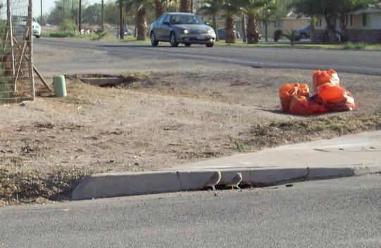
photo by Lineatus - dailykos.com
This photo above is or was common site around many of the desert cities and small towns around Imperial Valley. This photo I believe was taken somewhere around the Salton Sea, perhaps near Calipatria or Nyland. Storms drains and other culverts are great places to watch for these entertaining little guys.

Photo by Kathie Brown

Parking Lot Burrowing Owls by Kathie Brown
 The above photo was taken in Pima County Arizona, but is also illustrative of what could be seen in times past in and around Imperial Valley towns and cities. The attached link above has more photos of the parking lot habitat. 

Photo by Southwest Birders (Bob & Mary)

Somewhere near the Salton Sea near New River
and Brandt Road.

2010 Photograph by JOSELITO VILLERO
My most favourite place to walk around and view them was at the Imperial Valley College campus grounds. The last visit I made there was in the year 2000.  Burrows were everywhere, especially under concrete sidewalks in between the buildings and out near parking lots. Apparently the Owls never went to University to study about their prime habitats and where they SHOULD ONLY be found living. While I'm in favour of seeing the Owls out in the wild with natural settings, I have no problem with them adapting and actually thriving among humans, since we're not exactly going away any time soon. Good for the Owls. The little birds are feisty and protective of their burrow territory and  I remember seeing them fly up from the ground and attack the backs of a student's head if the student ventured a short cut through the School landscape from the parking area to the Student Union quad area. Back on September 10 2010 in the LA Times, there was a disturbing article about about their major decline in Imperial Valley which has the largest California population of Burrowing Owls. Here are some very important quotes from that piece:
 "An alarming decline in the number of burrowing owls in the Imperial Valley -- a Southern California agricultural area that had been considered a stronghold for the species -- has prompted calls for an immediate inquiry by state wildlife authorities."
"Surveys conducted by the Imperial Irrigation District show the burrowing owl population has dropped from about 5,600 pairs in the early 1990s to 4,879 pairs in 2007, and 3,557 pairs in 2008."
For me this is bothersome because these feisty little birds were thick as flies within city limits and so habitat loss wasn't exactly the issue. Seriously, in the quotes below it states that urban development has brought about habitat loss. NOT, in my 30+ years of traveling down there on a weekly basis, urban & agricultural development have always increased their expansion. I know I know, it's not ecologically kool to say that, but that is nevertheless my observation and 25+ years of experience down there. However something else may be the problem as the article made important mention:
"Statewide, the burrowing owl has been decreasing because of habitat loss by urban development, elimination of rodents it feeds on, pesticides, predation by domestic animals, vehicle strikes, collisions with wind turbines and shooting."
"Most of California's remaining breeding pairs of burrowing owls are concentrated in Imperial Valley, an area that makes up roughly 2.5% of the state's land, Miller said. "We still don't know exactly what is causing the declines in the Imperial Valley," he said, "but loss of suitable foraging areas from fallowing of agricultural fields due to water transfers and ground squirrel eradication programs may play a role." 
(Source)
Clearly some things could be eliminated as a possible cause for the Burrowing Owl decline down in the Imperial Valley if the L.A. Times article is true. As I've stated previously above, they were always thick as flies for decades down in Imperial Valley, so predation by feral or domestic cats and/or other animals, while certainly possible at times, to me would not be an issue. Their populations have been thick for decades down there and the past three or four years of decline if true would not really make much of a difference to me. Once again, these birds are feisty and defend territory fiercely. They certainly are not afraid to dive bomb the biggest and worst predator on Earth (Humans), so why would a bunch of Kitties suddenly be an issue ? No doubt they have been dive bombing cats or any other animal who get too close to the Den entrance and have successfully done so all along.
When Eco-Green really is a Red Light Warning

Image - SolUnesco
INDUSTRIAL SOLAR FARM IMPACT ON IMPERIAL COUNTY: HOW DOES SOLAR COMPARE TO OTHER LAND USES? IS IT REALLY ECO-GREEN ???

(Photo by: Kevin Cole)
The other issue mentioned was that the valley is experiencing  less agriculture which would limit food supply for mice (hence less mice) and other food sources like insects. Sure enough, Imperial irrigation district has made some dirty deals with San Diego to the west for more water. This means Imperial Vallet reduces irrigation water intake through the All American Canal and more water is allowed to be fed into the Aquaduct through the southern portion of the Mojave Desert and Joshua Tree National Monument which originates from Parker Dam upriver on it's way to San Diego. This is partly why the massive reservoir south of Hemet was built back in the 1990s to acommodate more water volume for San Diego. So less farmed fields because of less water and so-called eco-green alternative energy Solar Farms replaced crops. Less water and crops also mean less insects for lizards to feed upon. Lizards being another favourite food of Burrowing Owls. I've never really seen mice in the day time down there in the open, although I always did see plenty at night. Mice also are another one of those critters that never seems to have issues of being pushed aside for any reason. I don't think less fields being cultivated was an issue either. Besides, during the day time when I did watch them catching their prey, it was always grasshoppers, caterpillars and lizards. Anyone who has traveled through Imperial Valley any time, but especially at night has experienced a plethora of all manner of bugs hitting the windscreen and had to wash their vehicle of the zillions of little buggers plastering their car. So I highly doubt there are less bugs to be much of an issue either. 
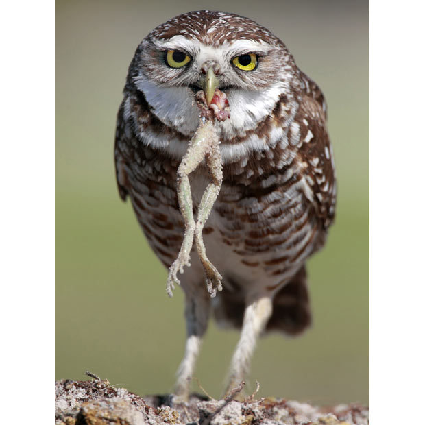
Photo: Megan Lorenz / Rex Features
Again, Frogs and Lizards are also on their menu and there are plenty of both in great abundance down there. And less water means less of these too. The article listed  Road Collisions and Humans shooting them no doubt are true, but those things have also always been around, especially the issue of Humans doing stupid things for sport, and while that no doubt has increased, I don't think it's a decline issue either. Such dangers have always been around. But also it just quite possibly might be the new class of Industrial Ag pesticide products which as we all know have  become more of an increased phenomena as of late. Along with GMO crops designed to manufacture their own toxic qualities and engineered to be deluged with their science-based chemical cocktail junk. If the Owl's food sources have become contaminated with this junk, then possible decline by these means would be my own best guess. Frogs & insects in and around the field drainage ditches where the excesses of irrigation water loaded with both chemical fertilizers and pesticides leaches from the fields into the drainage ditches on their way to the Salton Sea are the most likely another culprit. Again, all the other things have been present all along. The only increase in anything new would be that of the newer generation of chemicals contaminating the food supply and as we all know this has led to the decline of anything and everything beneficial to the Natural world. Ultimately, there is no answer for the control of pesticides. Giant Corporate business interests are going to do as they please as long as they load the coffers of all political entities. No one fingerpointing political ideology is exempt from doing whatever it takes to stay in power. Both sides do it despite what enviros want to blame. Going to bed with degenerate bedfellows would be considered a necessary evil to fight the good fight of worldview promotion. I honestly don't believe there is any humanly possible solution to changing these corporate giants as there are no long term historical precedents to put trust or faith in. Notice I said long term, as at times there have been some localized short term successes, but gradually memories fade and even these areas are once again in trouble. The collision with Wind Turbines mention while always possible is also most doubtful given the Owl's preference for ground, much like Quail, they prefer ground. I don't ever think I've seen them fly as high as a giant wind turbine - EVER. But it does add colour and sensationalism to any article. With all of this said, I would rather focus on what individuals can do to encourage more Owls on their own private land.
'Owl condos' are move-in ready and coyote-proof
Army mobilizes to increase Burrowing Owl habitat in Oregon
By Bruce Henrickson, US Army Umatilla Chemical Depot Public Affairs

By Bruce Henrickson, US Army Umatilla Chemical Depot Public Affairs

By Bruce Henrickson, US Army Umatilla Chemical Depot Public Affairs

By Bruce Henrickson, US Army Umatilla Chemical Depot Public Affairs

Speaking personally, I don't think it would be all that tough to find raw salvage materials from which to construct such artificial dens. This would be a fun project for anyone with the right type of  open landscape. Especially land that is too tough to develop or, garden or planting of  any trees because of the hard rocky ground like I had on one knoll on my old place. It would take some work with a long  steel or iron digging bar  , but I think the rewards would be worth it and the exercise and experience worth while from a health standpoint. Involving your kids would also go along way in appreciation which is radically lacking in today's modern society. Reading about something does NOT take the place of actual experience. I think the decline of the Burrowing Owls in Imperial Valley, if true, the experts are going to reassess what is believed to be the problem. Off hand they could interview people (especially old timers) who actually live down there as opposed to what official outdated text books and short sighted periodic field trips lead them to believe. Not only should the Industrial Ag Business products be looked into, but also the Ground Squirrel eradication programs by means of poison bates from the Imperial Irrigation District who have a sort of hate relationship for anything that would disrupt their precious irrigation canal banks.
More Incovenient Habitat Truth - But The Burrowing Owls Love It 😆
Mission Bay area in San Diego is a rich habitat for Burrowing Owls, but I have only found information about them from private nature bloggers and photographers or just your average citizen out for a stroll on a public walk and grabs a quick camera shot from their mobile phone. Let's focus on one particular habitat never really acknowledge by the nativists and that would be Sea Fig which is the most common ice plant we see olong California Freeway Systems. Most of the Facebook California Native Plant organizations and Eco-Groups hate it. They generally have an intolarance for most things non-native, but Sea Fig is one of those at the top of the list. Now the Burrowing Owls don't necessarily like it, however one of their best buddles love it. California ground squirrels (Otospermophilus beecheyi). They love to eat it and have made burrows everywhere in it. What attracts the Burrowing Owls are the Ground Squirrel Colonies where some old holes are abandoned.

Ground Squirrel Colony - Sea Fig
Photo - Fishbio

Sea Fig has naturalized along the California Pacific coastline and the native wildlife have adapted to it's presence with success. Much to the disturbance of the purest.


Ground Squirrel & Sea Fig - 

The California Ground Squirrel although native have often been demonized as an annoying pest themselves and been persecuted to the point of massive poisoning programs in many places. Like Imperial Valley where the Irrigation Districts ditches and berms have been kept clean of Ground Squirrels which has also hurt the Burrowing Owls.


Ground Squirrel eating Sea Fig
Photo - The Horticult

But the Squirrels do rellish the succulent Sea Fig stems


Ballona Wetlands Ecological Reserve
Photo - Jonathan Coffin

Then the Burrowing Owls take notice when they migrate back from places up north. They spot the ground squirrels colonies we miss and don'y sea. I have to believe they are many more Burrowing Owl colonies throughout the system, but most Freeway Sea Fid landscapes are just usually impossible access to humans and perhaps too dangerous for stopping and looking in many places. The photo above is at the Ballona Wetlands Wildlife Reserve up in Orange County where the environmentalists who champion the reserve's restoration have an all out war declared against the Sea fig. Sadly if successful in ridding the area of Sea fig, it will have a domino effect on the squirrels and then Burrowing Owls.

San Diego River Estuary - Mission Bay, California
Photo - Greg Gillson

This Burrowing Owl above was photographed by Greg Gillson of Greg in San Diego blog. He has since moved on up to Washington State where he and his wife have retired, but still photograph and document birds. This Burrowing Owl nest is near the San Diego River Estuary. The Owls do not dig nests, but they scratch our a wider den in pre-existing Ground Squirrel holes. Now where Greg and others have left off, perhaps other private citizen wildlife hikers and photographers can pick up the slack now that you know what to look for. Fiesta Island in Mission Bay also has a colony of Burrowing Owls. Below is Greg's blog about the Burrowing Owl and lots more photos.
Another Blogger Jo Quinn also wrote and photographed the same Colony of Burrowing Owls in 2016.

It's clear that the Burrowing Owls don't mind the supposedly unnatural settings that environmentalists insist they are not supposed to prefer, like artificial unnatural man-made constructs as opposed to the abandoned ground squirrel dens in out of the way wide open spaces. This doesn't by any stretch mean that no one should ever rally support for protecting historical colony habitats. They should. But it's nice to know the Burrowing Owls are not as sensitive as other wildlife who find it impossible to adapt to human intrusion. Of course, fortunately the Owls never went to University where such wild habitat legend myths are etched in stone are taught. Fortunately for their own survival, they don't know they are not supposed to adapt well around human activity. Pssst 😏, don't no one tell these little Owls that. 😉
~~~~~~~~~~~~~~~~~~~~~~~~~~~~~~~~
Further Reader References of Interest
COMMUNITY INSTALLS ARTIFICIAL BURROWS FOR BURROWING OWLS 
http://burrowingowlconservation.org 
http://burrowingowlpreservation.org
http://www.californiachaparral.org/burrowingowls.html 
Cuyamaca Woods Mountain Journal: "A Diversion to the Salton Sea: Our Annual Visit"
Cornell Lab of Ornithology - Burrowing Owls
http://burrowingowlbc.org

Friday, July 13, 2012

I love the Monsoon Season


I can remember planning trips in the summertime when the monsoon season was at it's peak, probably the beginning of August and looking forward to traveling to any points east as long as it was towards Arizona and away from California. I'd always look forward to that eventual Friday afternoon/evening when the day finally came to take off on our road adventure. I could hardly concentrate on work that day since the trip next week was so overwhelming all other thought processes. Heading out on Hwy 74 and leaving the San Jacinto Mountains finally coming to Indio, CA and turning right onto the eastbound on  Dillion Road to that on ramp of  Interstate 10 leaving Indio. The feeling was exhilarating knowing I was leaving California heading for that state line to explore the Arizona outback somewhere to a place I had never been to and only read about from my monthly subscription of Arizona Highways. As fun as the trip was, it was mostly that first day's drive I actually enjoyed the most. It was like a long  anticipated excitement of seeing a blockbuster film coming to the local Cinema, except this time Nature was going to put on the performance tonight, not Hollywood.

During the monsoon season, the mountains generally have their activity during the day and unless there is some unusual weather anomalies packed with extra energy it'll always stay quiet till the next day's afternoon. But out over the deserts the heat still has an energy output about it with it's warm powerful uplifts and the thunderstorms are usually at their most potent moments. You rarely see many of these storms in the middle of the day like you do at higher elevations, not that they can't happen, they can. But the norm has always been a nighttime event from my experience. Once we reach the top of of Chiriaco Summit on I-10, we begin to see the shows previews. Almost amazingly these storms would be right about the border along the California/Arizona stateline as if there were some sort of invisible energy barrier preventing them from further westward advancement. Days prior to leaving of course I'd always be checking the weather forecasts seeing if the conditions were right for the trip's monsoonal experience. Sure enough I wouldn't be disappointed


Since I'm no longer in the desert and mountains areas of the southwestern USA, the Southern California Weather Authority has been my next best virtual Nature entertainment venue for the real thing. Love that graphic. Weather reports like this one from the Southern California Weather Authority back in May of this year 2012 were common and beautifully illustrate the horseshoe pattern of Thunderstorm lines along the CA & AZ border regions. This is often the typical pattern as evidenced by storm patterns thus far 2012.

Photo by Blitzo - Mountain Project
 Here's a link to beautiful photos of Thunderheads at Sunset. Driving towards Arizona was never boring with a Thunderhead on the horizon. It was a preview of what was to come as we came closer ot it or it to us. Off in the distance as it grew darker was almost like being at a drive-in theater. The entertainment feature of the night was provided by Nature. I'm still amazed that city people pay all that money on Hollywood entertainment when the real life graphics provided by nature as so awesome.


Freeway heading east towards the border of 
California and Arizona


Downtown Blythe California, August 16, 1999. This was always a favorite pit stop for coffee on the road and whatever munchies we needed for the upcoming Light Show Displays we'd be seeing on AZ Route 60 traveling north off of Interstate 10 to Preskit.


Quartzite Arizona
Sometimes before turning off I-10 and heading north on Route 60 towards Wickenburg, we'd stop at a MacDonalds there in Quartzite Arizona. It's mostly a series of Truck Stops and huge wintertime SnowBird hangout, but lately it seems to have become more of a permanent location for many retirees and others who found they loved the deserts year round, much like the changes in residency that came to the Coachella Valley from years previous. Many of these areas were traditionally known as summer ghost towns. No more ghost towns, the word is out. Desert environs are actually very Kool all year long.


Once we turned off at the Rte 60 Junction near the first tiny community of Brenda, it was usually from this point on that we'd really hit the heavier stuff. However until the heavy rains were encountered, rolling down the window and allowing the fragrance of Croesote Bush to permeate the car's interior was a must. Oddly enough the scent is reminiscent of a highway's asphalt, but with a clearly distinct refreshing energizing effect on the senses. This plant actually has some interesting natural medicinal properties. It was once utilized heavily by the Herbal Industry who actually mistakenly call it Chaparral which is merely a plant community, but was also banned by the FDA whose bed fellows at the Pharmaceutical industry were disturbed by it's potential at detoxifying the body and gradually reversing cancer. It's since been unbanned.

Usually we'd hit heavy rain at Harcuvar just before Salome AZ. At Salome we'd break to let the storm pass, refilled my large king-sized plastic Texico Coffee Refill Mug, hit the Salome Cafe's antiquated Loo Office to finish some paperwork and back out on the road again. Then we'd hit another squall line of rain between Wenden to the north and Aquila. 


credit: RoadTripz
We'd turn off onto Hwy 71 heading for the town of Congress and Junction 89. From that point winding up the switched back road of Yarnell Hill we'd stop at the viewpoint at the top, look back down at the desert floor below we just traveled through and watched those previous Thunderbumpers making their way west into California. All the while the moist cool refreshing scent of creosote bush ever present. These first few hours on the first day on any of my trips were always memorable. Our stay in Preskit, Sedona, Grand Canyon and other point's north had their own monsoonal events during daylight hours, but that specific late afternoon early evening drive was always the best  highlight for me. As with anything you should have a measure of caution and don't drive like an idiot in such weather. If rain is heavy pull over. If there is a dust storm preceding this pull over. If a dip in the road is a raging torrent wait it out, don't chance a crossing.


Wow, who knew ??
A big part of my fascination with monsoonal moisture events was studying the mechanics of the actual cloud and storm formation themselves. What makes it all tick ? Why does it more often than not happen over there than here, etc ? More on that in another post. But viewing it for me with just the right equipment was just as important. Take for example this often posted corner photo view of my former covered porch deck which was the perfect view portal as a monsoon lookout point. Why right there on the corner next to my steps I'd park my favourite viewing chair which overlooked all of Burnt Valley & Santa Rosa Mountains to the east, Anza Valley to the west and Thomas & San Jacinto Mountain straight out in front to the north. 

And the perfect chair for me was a rounded saucer bowl shaped Rattan swivel chair which was technically called a Papasan Swivel Rocker style chair. This chair to me was/is the most perfect chair for me. I could dump all living room furniture and live with only a lamp and this chair. Fortunately I'm married and as a result civilized and not single and neanderthal. It had a heavy base much like the common Rattan Swivel Rocker with the arms like the photo to the right here. The only exception was of course the chair itself which was saucer or teacup shaped with a giant heavy duty canvas cushion pouch pillow in the center. This pouch-like cushion would conform to anyone's shape or size. I often would come home from work hot and tired and slink down into this comfortible  pillow and almost fall fast asleep. Okay so I did fall asleep quite often. But viewing thunderhead cloud formations from this vantage point and with just the proper equipment made this time of year the most perfect of all the seasons. 


I'd often curse the wintertime when on that same deck in a January we experienced hurricane force Santa Ana winds from the northeast with frigid near Zero Temps blowing off the snowcapped El Toro Peak to the east which would cause me to wonder what am I doing here ??? Then of course every summer I was reminded why. Yes, I miss Anza.


Note:
I am very serious about cloud formation and thunderstorm anomalies. Clearly there are intriguing questions like why in all the mountains or deserts in certain specific regions or locations within those regions does it chance rain more there than other places ? What causes the clouds to form quicker on some locations before moving onto others. While there is a observational sense of randomness to it all, you'd be surprised how ultimately very organized, and conveyor belt mechanical these formations can really be. I'll have some charts and diagrams and other illustrations later and will incorporate vegetation's influence on it all. Enjoy the season in the mean time.


Monsoonal Cloud Formation & Rainfall References: 
Earth's Vegatation Effects Global Cloud Formations

Earth's Internet: Electrical Conductivity of Trees 
Trees Recharge Earth's Electromagnetic Field 
Are Rainforests Alone Solely Responsible For Earth's Climate Mechanisms ?