 |
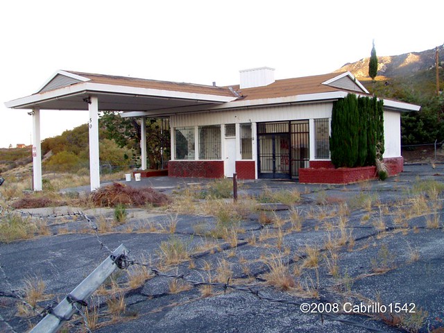
| Image from Press Enterprise Press Enterprise: BACK IN THE DAY: Ribbonwood was popular rest stop |

 |
| Oct 2008 - Cabrillo1543 |
 |
| Cabrillo1542 |
 |
| Rancho Fruit Market in Temecula |
 |
| Image from Foursquare |
This is probably one of the earliest roadside Fruit stands which much much later became very up until this very day. Hmmm, somewhere at the end of this road with a detour left turn at Paradise Corners to Anza and beyond, there use to be the well known stop called Rancho Fruit Market in the Temecula area right on Hwy 79. It has now moved to old town Temecula after a fire and redevelopment of the land it was once on. But Wilson's place was also another place where one could buy fruits and vegetables, enjoy a cold drink under an old Ramada (probably made of Redshank) or even rent a Cabin or Kamp spot for the night. Maybe even the weekend. Notice the skyline in the background of Santa Rosa Mountain ?
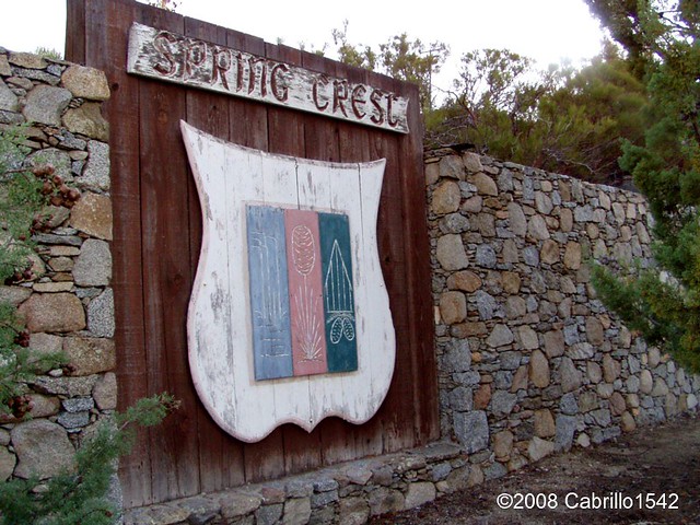
I found another bit of history that I had read many years back and now it has even been more recently updated. I think readers will find it both sad yet interesting at the same time. In 1959 there was a mystery of sorts surrounding the disappearance of a young woman named Louise Teagarden. She was an outdoors person and friend to even Wilson Howell at the Ribbonwood Camp where she learned much of her outback survival skills. Yet strangely enough on this one occasion, she lived for a couple of months in the wilderness before dying. Her remains were not found until 1991 in a cave in the Palm Canyon Drainage area of which the Spring Crest area (Ribbonwood) on Santa Rosa Mountain is very much a part of the upper headwaters. The Sierra Club actually published an interesting story about Louise Teagarden, who was very experienced as having outdoors survival skills and yet she mysteriously died. Rather than tell the story over, you may read it for yourself here.
Sierra Club: "Lost and Found" - Louise Teagarden's Death Still a MysteryFor those a bit more on the impatient side (you really should read it though), there was also a video of the recent 2008 search made for that very cave where she was found. It's only about ten minutes. Writer Ann Japenga, Harry Quinn & Theresa Pawley are making an attempt in the video to locate the actual cave where Lousie Teagarden's remains were found over 30 years later. Very interesting and informative video.
 |
| Image - SummitPost.org |
After 24 years of traveling this highway back and forth to work, I always passed this single lone beautiful tree and wondered about it. Where did it come from and why is it here of all places miles from any other group of Jeffrey Pines ? This isn't the first time I wondered about how and where certain species of out of place species of trees came from. Hwy 74 west of Mountain Center was another example, which I have previously alluded to in in an earlier post of my discovery of the road construction of Hwy 74 which completely & very deliberately diverted an entire stream (almost a small river) by means of a bulldozer and cutting a path towards the South Fork of the San Jacinto River Canyon. The result is an entire mountainside washed & fell away in a landslide at that canyon with no real possible way of repairing it. And amazingly no one noticed or at least has admitted this. More on this after I actually go out and photograph this area next summer. Incredibly, some extensive Chaparral removal has been conducted around this tree and on up the hillside. Some things never change.
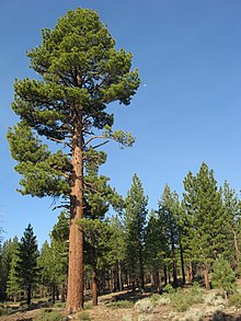 |
| Wikipedia Example of Jeffrey Pine. Much larger than the stunted Hwy 74 lone pine tree, but from where did the original seed come from ? |
Tomorrow I'll have Part II which will focus attention on the switched back logging road you can easily view from Sugar Loaf Mountain Cafe. I'll tell you about the man who built that road and the conversation we had on why he was contracted to build it. Much of of the story he told sounded like forestry politics as usual.
~~~~~~~~~~~~~~~~~~~~~~~~~~~~~~~~~~~~~~~~~~~~
Of Further Reading Interest:
http://www.palmspringslife.com/santarosa/
http://www.annjapenga.com/Images/articles/wHwy74.pdf
http://www.riversidecountyhistory.org/SJM.htm
http://www.santarosacahuilla-nsn.gov/home.htm
http://www.annjapenga.com/Images/articles/wLostandFound.pdf
The 660 acre horse ranch is now deserted except for a caretaker and his family. I often drive by it and think what a wonderful spot it would be for a thriving horse rescue! There are beautiful corrals, a track, and even a stallion barn. What a wonderful thing it would be if it could be used as a horse rescue operation! ...maybe if someday I win the lotto!
ReplyDeleteI was looking on Google maps and clicked on Satellite and close up inspected the whole place. The ranch house waaaaaay out in the back of the property looked uninhabited, while the front main house, barns stables and other out buildings looked very abandoned and over grown with weeds. That pickup truck at the home in the back though looked exactly like the same one she and Red ran around in all over those mountains for years.
DeleteWell, somebody does come to take care of it because I've seen a truck stop at the entrance, punch in a code, and go in. I often do see cars and trucks parked there as I frequently take that road down through Burnt Valley just to see what's going on...seems like such a waste to let it go when it could be used as a horse rescue (just my opinion...) All that land, all those corrals and barns and sheds...
DeleteAnd, yes, I remember reading about Louise Teagarden. What a sad story.
ReplyDeleteMore recently, and again sadly, there was also the murder of a family that lived at the end of the dirt road Palm Canyon Drive and Alpine Road (in Pinyon)...the parents were shot in their house and their teenage daughter was also killed and her body set on fire. I believe this was in 2006...The surviving family members returned last fall and set up a $10,000 reward for information about these murders, which have never been solved. They have hired a group of retired detectives to assist them...the Friedli family, I recall...you can read about it on the Press Enterprise website. Here's the link: http://www.pe.com/local-news/riverside-county/hemet/hemet-headlines-index/20120806-pinyon-pines-family-seeks-new-help-in-solving-06-triple-homicide.ece
ReplyDeleteThis bugs me, I hit the wrong stupid button for a reply and deleted, but here's a copy.
Deletetrav4adventures
"Well, somebody does come to take care of it because I've seen a truck stop at the entrance, punch in a code, and go in. I often do see cars and trucks parked there as I frequently take that road down through Burnt Valley just to see what's going on...seems like such a waste to let it go when it could be used as a horse rescue (just my opinion...) All that land, all those corrals and barns and sheds... on"
Yeah, I can only see things from Satellite photo and I cannot tell you the year when taken. Yeah it's a shame some positive isn't being done. At least try some reforesting some areas.
I have to be honest, all those areas like Pinyon, Anza Aguanga and countless others have criminals and nut cases out there and generally everyone knows who they are. Anyone who moves to the backcountry should always know the good and the bad potential nieghbours. I've had my share of weird experiences.
ReplyDeleteSo true...so true.
DeleteAnd, I want to wish you and your wife and family a MERRY CHRISTMAS! Are you still getting snow? I'm actually heading up the hill this morning and it's cloudy there.
Actually it stopped, but it was a dry ice crystal type of snow which blows easily in wind and piles up snow banks. One year it piled up as high as the second story window on the south side of our house. All the pathways looked like WWII trenches in Stalin Grad. Suddenly I knew what it felt like to be a German Soldier in Russia.
Delete